From: District Wire
7 free apps to help you get around D.C.
![]() (WMATA)
(WMATA)
Washington, D.C. is a cosmopolitan mecca for all kinds of people — after all, it is the nation’s capital and a booming city. With that, navigating the city and its transit system is an important skill to learn for getting to work, college and touristy places like the National Mall. To help with what can be the overwhelming process of public transportation, here are our favorite free apps on the Apple App Store.
One of the most popular forms of transportation is Metrorail, so the app called iTrans DC is useful because it allows the user to navigate the entire Metro map on a mobile phone. It also keeps track of the service alerts and delays.
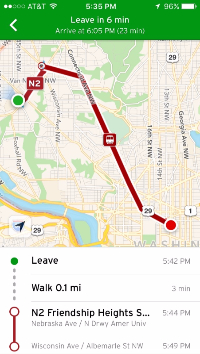
The app titled Transit (pictured right) not only outlines the estimated time of arrival of Metro trains, but also Metro buses, Uber, Capital Bikeshare and even shows local bike paths. A new feature also alerts users when reaching their intended stop. It comes in handy when figuring out the best mode of transportation to plan your day. Transit is based off of the user’s current location, so the app can be used in any area, not just Washington, D.C.
DC Metro Washington WMATA Map and Route Planner
Similar to iTrans DC, the DC Metro Washington app provides an interactive map of the Metro, but also includes a feature called Route Planner that allows the user to blueprint travel plans based upon Metro stops.
Like Transit, Transit Stop has a map of the United States, so it is based off current location. This comes in handy for Metrorail and Metrobus because all routes and train lines are listed, as well as visualized on the map. Although Transit Stop does not have the bicycle feature that Transit does, the app itself is clean-cut and easy to use.
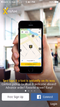
In terms of alternative means of transportation in the greater Washington, D.C. area, taxi services run throughout the entire city. The app called mytaxi is clear and concise when in need of hailing a quick cab. Tips can even be paid for digitally through the app.
Another extremely handy app, titled DC Next Stop, is strictly an app that calculates all of the Metrobus stops in the entire Washington, D.C. area and how far away a bus is from each stop. The app constantly updates itself when buses are running late.
If all else fails, there’s always Uber. Quite possibly the most popular app for ridesharing, the user can order a car, uberX, uberXL, uberBLACK, uberSUV or taxi at any hour of the day — based on how many people need to travel. The payment for Uber is electronic through the app, and each account requires a credit card to be connected.
districtwire@theeagleonline.com
Follow @districtwire